Mesa de Roldan is flat-topped extint volcano in Spain. At the top sits tower and a lighthouse. The tower made its appearance in one of the scenes in series Game of Thrones. Right at the foot of the volcano is also popular beach Playa de los muertos. Enjoy the beach or the view on it from view point above.
Agua Amarga is small fishing village in Spain. It is in the northern part of the Cabo de Gata-Níjar Natural Park, offering beautiful coastal hikes. The village is popular for its small caves on the right side at the beach. Another popular site are ruins of mineral mine complex just above the village, which you will pass as part of this hike.
More information about Agua Amarga HEREand about Mesa Roldan HERE
The hike starts on the left side of the beach in Agua Amarga with very steep and hard climb
The trail is posted with white and blue stripes, but you need to look well as they are not frequent and sometimes hard to spot
GETTING THERE
Barcelona– 750km (7h 30min)
Granada – 205km (2h 10min)
Murcia – 190km (2h)
By car: Park at free parking lot outside Agua amarga Camper Park or elsewhere in the village. It is also possible to reverse the hike and park at parking lot of La Playa de los Muertos, but note that the parking is paid there.
By public transport: Take bus from Almeria, limited timetable.
Camper/ Van overnight stay:
Paid – Agua amarga Camper Park is great base for various hiking options. The trail starts at the other end of the beach, not far from the campsite. Price in 2025, off-season 15 EUR, 5 EUR electricity, 1EUR/5min shower.Campsite has no website and they do not make reservations.
Free – Not available in the area
TRAIL NAVIGATION
While it is marked trail, I found the navigation pretty difficult. There are many small side trails and the marking is not always visible. It is still possible to follow without navigation, but would recommend getting some form of navigation in advance.
Start at left end of the beach (facing the sea), take steep trail uphill. Follow while/blue stripes on rocks or poles all the way to Mesa Roldan, from there go to the top and then on the road back down. I recommend visiting the beach Playa de Los Muertes. You can return back to village on small trail along the main road. Note that the last portion is on windy road with no shoulder.
Example of the route on Wikiloc HERE. I have done almost the same loop but without the small loop side hike just before Mesa Roldan.
Old mining site just above Agua Amarga
The trail takes you right through the old mining site. Keep an eye on the markings, they might be hard to spot but they are there.
TRAIL DETAILS
Old mineral mine
Start with very steep hike at the end of the beach, passing the fishing building. The trail is very steep and with a lot of scrambly rocks, so take your time. For this part, hiking poles might be handy. After reaching the top, enjoy many beautiful old ruins around. Make sharp turn downhill to the larger complex. Here is where the navigation starts getting tricky, as there are many small trails and you need to do several turns. But marking is there, so you can find the trail if you pay attention.
The plain
Now you need to cross a plain of shrubbery before the hill. Pay close attention to marking, if you dont have navigation, best to backtrack to the last marking. However the direction is also very clear as you see Mesa Roldan right in front of you, so it is easy to keep general direction. If you get close to the sea or cliffs, make sure to return swiftly as the main path is inland, not along coastline. The terrain on this part of the trail is mix with easy small trail and some steep but short technical descent/ascents.
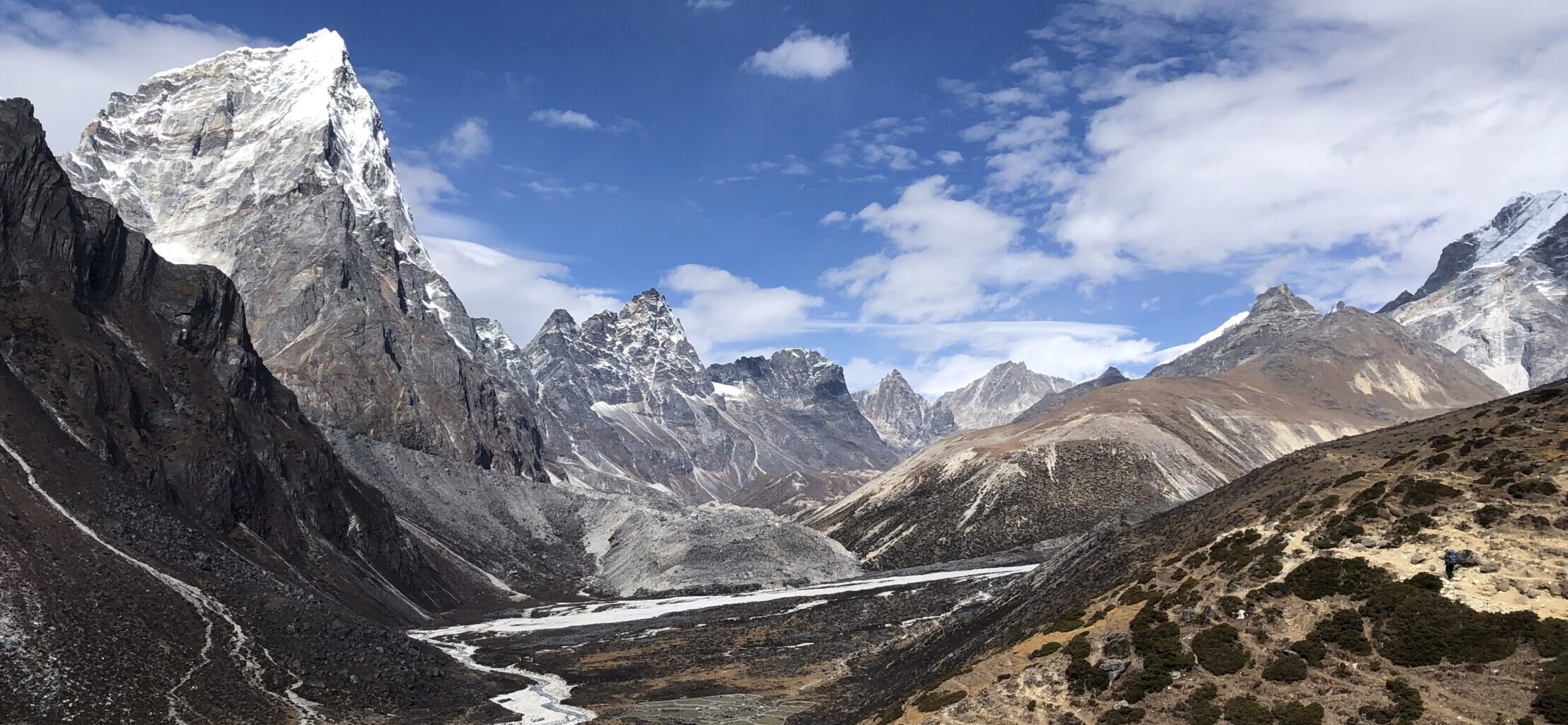
View on the plain from the climb to the Mesa de Roldan
The trail on the plain is mostly easy with couple of harder sections
Mesa de Roldan
Eventually you will reach bigger road with some houses. At the big villa, turn to your right as per white/blue marking. The climb to Mesa de Roldan is easier than the previous climbs on this hike. It is easy gravel zig zag path with some loose rocks, but not too difficult. After you reach more than half of the hill, you will get to split in the path. Follow white/green flags to your right towards the lighthouse. There is also a signpost to help with the navigation. The path from here is very easy, wide and at easy incline. Enjoy great views until you reach the tower at the top. From here you can return the same way, but I recommend continuing to Playa de los muertos.
Playa de los Muertos
To reach the beach, continue on the tarmac road all the way down. This can be busy with cars, so take care. At some point you will see path on your right heading to the beach, this trail is medium difficulty. Enjoy the beach or climb up to the viewpoint. Look for rocky staircase trail right at the start of the beach on the left side (while facing the beach). The viewpoint offers great views on the beach as well as the village of Carboneras.
Beautiful lighthouse at top of the hill
The tower at top of the hill. This was also shooting site for Game of Thrones series.
Return
You can return the same way back, but you can take easy/shortest way possible, which is along AL-5106. From the viewpoint, head to the parking lot and continue to your left. There is wide gravel road parallel to the main road. Take the gravel path. At some point, the gravel path will turn into small trail, that goes all the way to Los Ventorrillos. From here you either have to walk on the road itself, taking care for the traffic as there is no path or shoulder. Alternatively you can go to the left towards the mining site (make sure not to enter the private housing area). But keep in mind that you will have to descent on the scrambly steep trail, which I do not recommend. Unfortunately there is no easier way to get to Agua Amarga unless you add hike of Lucainena de las Torres to walk longer way around this area.
Beach of the death is worthwile stop
Descent from Mesa de Roldan to Playa de los muertos is on tarmac road
OTHER DETAILS
Tree coverage: No tree coverage, no shade on hot days. Bring sun protection.
Geocaching: There is one geocache on Mesa Roldan and no Adventure labs along the trail.
Dogs: It is possible to the trail with a dog, recommended to keep the dog leashed. It might be straining for some dogs/breeds. Bring enough water for your dog.
Shoes recommendation: Best completed in hiking or trail running shoes with good profile
Hiking poles: Not necessary, but can be helpful during the climbs/descents.
Trail running: It is possible although challenging due to navigation and terrain. Best for experienced technical trail runners.
FACILITIES
There are no facilities along the way, plan well ahead. Make sure to take trash back with you
Restrooms: No public toilets, visit restaurants in Agua Amarga
Restaurants: In Agua Amarga
Shops: In Agua Amarga
You can return on nice trail along the road
However the last part is descent to Agua Amarga on a road without shoulder, watch out for traffic
PERSONAL EXPERIENCE
I completed this hike in March 2025 on Monday. I had sunny but windy conditions, extremely windy at the top of Roldan. The trail was not busy at all, but might be busier during weekend in nice weather. The beach with the viewpoint was very busy.


2 Responses