Gammelveten is peak on Senja island in Northern Norway. Elevation about 462m, it is not very tall but provide 360 views to the surrounding areas. It is mostly well marked, depending on the route you take. I would recommend this hike if you are staying at or around Senja campsite or village Vesterfjell. While it is nice trail, I do not recommend traveling specifically for this hike as there are nicer hikes on Senja island.
Map with information at the trail head
Senja camping has their own loop and will provide you with the map. I found this loop challenging at times.
GETTING THERE
Oslo – 1545km (21h 25min)
Tromso – 175km (2h 30min)
Narvik – 160km (2h 25min)
By car: Set gps to Senja campsite and after additional 500m there is very small free parking lot. If you start at this parking lot, your hike will be closer to 9km instead of 10km.
By public transport: No public transport available to Senja camping area. There is public transport to Versterfjell village from Finnsness.
Camper/ Van overnight stay:
Paid – Senja camping, nice campsite. Note it is children friendly campsite and has several activities for children, so it can be busy and noisy (2025 price per night 360 NOK, including electricity, showers 10 NOK/6min). The trail head is about 0,5km away from campsite.More information about campsite HERE
Free – Not available near to Gammelveten trail head
The first part is very easy on wide dirt road, going up at nice incline. See the red marking
The dirt road ends shortly after wreck of a camper
TRAIL NAVIGATION
Navigation from camping up to Gammelveten is relatively easy. The start of the hike is only marked by directional signs, but you walk on single zig zag wider road without many turns. As you go higher, the route becomes marked by red dots on various landmarks such as stones and trees. Once you get above tree line, the navigation becomes slightly tricky, you will just need to pay close attention to the markings.
If you decide to complete the loop as outlined by the campsite, you will need to pay really close attention. One part leads through rugged terrain including steep slope descent and eventually to small paths. One turn was not marked well so I went off the trail, but realised quickly.
You can get physical map available at the reception. It did help to understand general direction, but it was not helpful at some turns and locations.
I found wikiloc gspx route which you can use for the Gamleveten peak (and return same way back) or if you want to complete longer loop.Wikiloc trail with gpx map available HERE
The trail after the camper wreck is single trail, you can see Gammelveten in the distance to the left
Some turns have signs, such as this one at the start of the bog
TRAIL DETAILS
Campsite to the bog
From the campsite turn right on the road until you reach small area, which can be used as parking lot. There is a map for the trail. Take the left path which starts immediately your climb, this is nice wide path at comfortable incline. After short while, you will need to turn to your left again as per sign to another wide road, this road will be bit steeper zig zag for at least 1km. The terrain is very easy, main challenge is from the elevation gain. Eventually you will reach wreck of old camper, where the wide dirt road ends. After this follow the red dots on single narrow forrest trail. The terrain will become slightly harder with some rocks and tree roots and bit of up and down, but still pretty easy. Continue until you get to the bog which starts above the tree line.
Bog to Gammelveten
Once you reach the bog, make sure to turn to the left, there is also sign on the ground. The navigation might be slightly harder from here as there are not as many landmarks. Make sure to locate the trail and not wander around since the area is boggy and the trail leads through the driest parts of the bog. Otherwise the terrain is flat and easy. Eventually you will reach the turn to the right for the final climb. This is the least marked part of the trail, but if you keep an eye for the red dots, you will find the trail. It is also bit scramble over the rocks, but its only short part before you get to proper trail and reach the peak.
The part between camper wreck and the bog, you start to have better views as you getting above the tree line
Some parts of the trail might be bit overgrown, but its still easy to follow if you pay close attention
Return
You have 3 options on how to return to the start
Option 1
Return same way back, I find this would be the easiest especially if you have children with you
Option 2
9km loop marked by Senja camping, I do not recommend this option if you are not used to steep descents or if you are not good at navigation. Most of the route is fine and easy, similar terrain to what you have done on the way up, but there is one part of the trail which is very tricky, very steep slope without prominent trail and some fallen trees. You will need to make your own trail through high fern meadow. The turn to this route was not marked very well either and I almost missed the turn. Also later on there is one sharp turn which is not marked well (It is after small creek crossing, you need to go immediately to your right instead of straight ahead). The map provided by the campsite is not sufficient and I have not located any gspx map to help with guidance for this loop.
Option 3
Longer loop (13km) through Versterfjell village. If you dont take the turn at the Senja camping site sign during the descent, you will arrive at Vesterfjell village and from there you can take flat-ish path back. I have not completed this route, but there is wikiloc gspx map available HERE
The area after Gammelveten peak
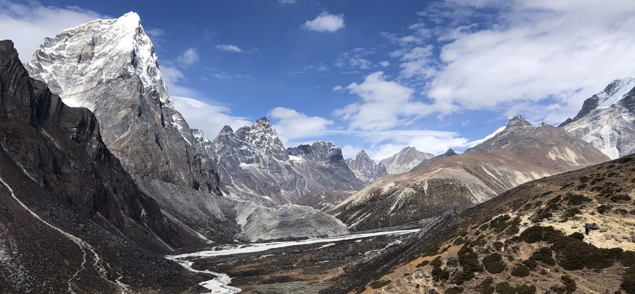
Views from the top
OTHER DETAILS
Tree coverage: Most of the trail has tree coverage, but also exposed areas at the top, bring sun protection
Geocaching: No geocaches and no Adventure Labs.
Dogs: It is possible to the trail with a dog. Dog must be leashed.
Shoes recommendation: Sport or hiking shoes with good profile, waterproof shoes recommended after heavier rain
Hiking poles: Not necessary, but might be useful, especially on descent.
Trail running: Best for experienced trail runners. The terrain is mostly easy with only some slightly more technical parts, but I found it bit hard for running
Nice views on the descent
This was the hardest part of the trail during descent, there is no prominent trail, you cross steep hill with plants and fallen trees
FACILITIES
There are no facilities. Plan well ahead.
Restrooms: Not available
Restaurants: Not available
Shops: Not available
PERSONAL EXPERIENCE
I completed Gammelveten on Saturday. It rained in the morning and was cloudy but warm. The forecast said some showers are possible, but I did not have any rain. I have met only one (local) person on the trail. I do expect the trail might be busier in nice weather or during weekend due to the campsite and another trail leading from a small village.
ProTip: Bring bug spray, there was decent number of flies, mosquitos and other insects, especially around the boggy area.
You will need to cross couple of creeks but they are very short and its easy to get across without getting wet even in regular shoes


