Alteidet is very small village in the north of Norway. Alteidet was old trading post which was not rebuild after burning down during World War II. It is right on busy E6 route. It is great area for hiking and fishing.
Mikkaltinden is small peak overseeing Kvaenangen fjord, from Alteidet village. It is 497 above sea level. At the top is communication tower. It is nice hike with great views once you get above tree level.
While the hike is really nice, I do not recommend to travel especially for Mikkaltinden hike. However it is definitely worth it if you are already in the area. If the hike to Laslettind was marked, it would have been worth the diversion since it has really nice views from the start and it leads higher.
Map with trails in the area of Alteidet (map at the campsite)
Trail head for Mikkaltinden. Trail is not marked but once you get on this road it is single road until the top
GETTING THERE
Oslo (through Sweden)– 1805km (22h 15min)
Tromso – 305km (4h 30min)
Alta – 80km (1h 10min)
By car: Turn from E6 on road Fv365 towards Jokelfjord. After 2km you will find large parking lot on your left but keep driving little further to find smaller parking lot also to the left. The hike is to the right, there is space for 1-2 cars, but best to park on one of the previous parking lots before that.
By public transport: Bus station at Alteidet
Camper/ Van overnight stay:
Paid – Alteidet camping, expensive but nice campsite with great fjord views (2025 price per night 410 NOK, including electricity and showers). All facilities except grey water emptying. The hike is about 2km away through forrest, not marked. The trail to the start of the hike is harder than the hike itself. More informationa about campsite HERE
Free – Couple parking lots on Fv365, one is at a lake. Also seen one at the parking lot for the waterfall hike
If you are starting at the campsite, you need to find shortcut to the trail, look for bit wonky bridge leading to the woods
The path to Mikkaltinden trail head from campsite is harder than the Mikkaltinden hike
TRAIL NAVIGATION
Navigation is very easy. The route is not marked but it is one road without any turns. Find the starting point with the sign and then continue up. No additional marking or sign posts.
It is possible to walk on the roads for 3,5km, but I do not recommend walking on the E6 since it is very busy also with trucks. It is best to take shorter forrest path for about 2km. Take the smaller road to the left until you get to very small “bridge” leading into the woods. Start very steep forrest trail until you reach slightly bigger path, just continue up on this path. You will end up on the big parking lot on FV365, just continue further on the road until you reach the start. This hike can be challenging due to rocky and steep trail, it is much more difficult than the hike itself.
Alteidet waterfall
Path to Kavringen
Mikkaltinden
Once you get to Mikkaltinden the navigation is easy and the terrain also. It is wide gravel road, the terrain is very easy, there are some rocks, but they will not causing neither slipping or tripping. The main challenge of this hike is the climbing, but the road is zig zag creating nice incline. For this reason I rate the trail as easy/medium. It is good to bring some bug spray that works well on flies. There were several insects including bees, horse flies and mosquitos but flies were the main challenge. The first half of the hike offers almost no views, only once you get above tree level.
OTHER HIKES
Alteidet waterfall
Down at the village is very short hike to a waterfall. It is nice and peaceful waterfall. More info HERE
Kavringen
Above the waterfall is hike to Kavringen, it starts with very steep climb past the waterfall and then joins nice tractor road before turning for steep uphill again. I turned back at the 2nd uphill, but it seems like nice hike also. It is very well marked by red dots on various landmarks.More info HERE
Trail head to alternative hike to Olderbakktind
Views from the trail to Olderbakktind, you can also see Mikkaltinden
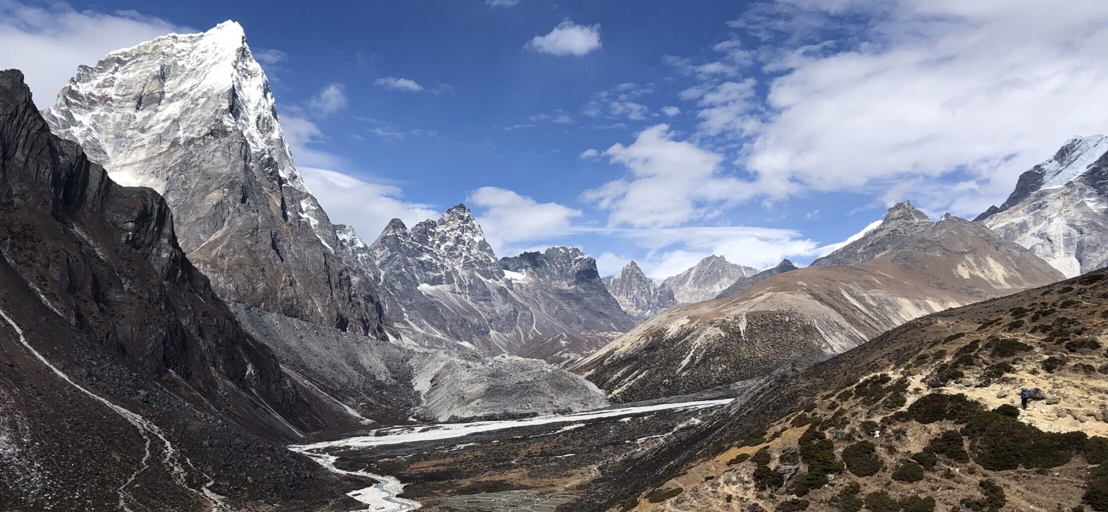
Laslettind, Olderbakktind, Koppartind
At the same parking lot for Mikkaltinden, you can find also start for hike to higher peaks starting with Laslettind. This is really nice hike, however it is not marked at all. It starts easy with trail which is very prominent and clear. Enjoy easy trail with minimum rocks or difficult terrain, the main challenge being the climb that becomes steeper and steeper. After certain point, the trail becomes very unclear. I had wikiloc gspx map (just on google maps) but I was not able to find/locate trail and ended up walking over the bushes and on steep slopes or over rocks. Later I found official gpx map, perhaps it would have been slightly easier with it. Since I was alone and there was nobody else on the trail, I turned around, but even getting half way was really rewarding since you get really great views from the start. Due to navigation, I rate this hike as challenging. More information HERE
The entire trail is on very easy wide path
Another example of the terrain with different view
OTHER DETAILS
Tree coverage: No tree coverage, bring sun protection
Geocaching: No geocaches and no Adventure Labs.
Dogs: It is possible to the trail with a dog. Dog must be leashed.
Shoes recommendation: Any sport shoe is suitable. If you do other hikes, make sure to have shoes with good grip
Hiking poles: Not necessary unless you are doing other hikes in the area.
Trail running: Great for beginners for training hills on non-technical terrain
Peak of Mikkaltinden
View on Mikkaltinden at the start of the hike
FACILITIES
There are no facilities on the trail or even at Alteidet. Plan well ahead.
Restrooms: Not available
Restaurants: Not available
Shops: Not available
PERSONAL EXPERIENCE
I completed Mikkaltinden on Monday. It was hot and sunny weather. I have encountered two couples on the trail. It might get busy during weekend, especially in nice weather.
I met two people at the waterfall and towards Kavringen. There were no people on the hike towards Laslettind.


